KEY FINDINGS
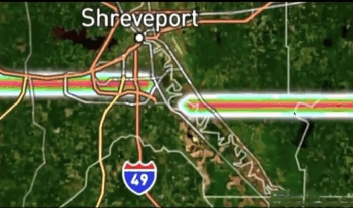
- On December 22, 2025, a sharply defined, perfectly straight line suddenly appeared on U.S. weather radar, stretching more than 3,000 miles across the country before vanishing into the Atlantic Ocean.
- The anomaly was not accompanied by storms, rainfall, or known atmospheric fronts, yet it displayed dense radar returns typically associated with heavy precipitation or concentrated material.
- As experts review the data, the central question remains unresolved—whether this was a rare but explainable radar artifact, or an atmospheric interaction not yet fully understood.
A continent-spanning linear feature appearing on U.S. weather radar has prompted scrutiny from meteorologists and data analysts after defying known atmospheric patterns.
By Samuel Lopez | USA Herald – Weather radar systems across the United States recently recorded a striking and highly unusual anomaly: a straight, continuous line extending from the American Southwest, through the Deep South, and out into the Atlantic Ocean. The feature appeared on Doppler radar imagery as a dense, sharply bounded structure with a dark core—an intensity signature meteorologists typically associate with substantial atmospheric density rather than ordinary rainfall.
Publicly available radar data shows the line traversing Arizona, Texas, Louisiana, Mississippi, Alabama, and Georgia without deviation. Unlike known weather formations, the structure did not curve with prevailing winds, dissipate over time, or fragment as it crossed varied terrain and atmospheric conditions. Instead, it maintained consistent width, intensity, and alignment across thousands of miles.
According to meteorological principles, weather radar detects returned energy from objects in the atmosphere—most commonly raindrops, snow, hail, insects, or dust. In rare cases, radar artifacts can occur due to interference, calibration errors, or anomalous signal propagation. However, experienced weather analysts reviewing the imagery note that conventional radar glitches typically appear as localized spikes, radial bands, or temporary distortions—not continent-scale straight lines with uniform density.
No severe weather advisories, storm systems, or atmospheric rivers were present along the anomaly’s path at the time it appeared. Data from multiple radar stations showed the feature persisting as it crossed coverage zones, reducing the likelihood that it originated from a single-station malfunction.
Officials have not issued formal statements attributing the anomaly to a specific cause. Data produced by radar networks overseen by organizations such as National Oceanic and Atmospheric Administration is routinely reviewed for quality control, and experts caution that unusual radar signatures—while rare—do not automatically indicate extraordinary phenomena.
Analysis and Contextual Insight
What makes this event notable is not merely its appearance, but its scale and geometry. Atmospheric processes are inherently chaotic. Even large-scale phenomena such as jet streams, squall lines, or dust plumes exhibit curvature, diffusion, and variability over distance. A perfectly straight, sharply bounded feature persisting across multiple climate regions challenges conventional expectations.
There are plausible explanations that remain under evaluation, including coordinated radar interference, data-processing artifacts affecting multiple stations, or unusual atmospheric ducting conditions that allowed signals to propagate in unexpected ways. Each possibility, however, presents its own technical hurdles when applied to a feature of this length and consistency.
From a broader perspective, the incident underscores how dependent modern forecasting and situational awareness have become on complex sensing networks. When anomalies arise that fall outside established patterns, transparency and rigorous analysis become essential—not to fuel speculation, but to maintain public trust in the systems designed to monitor the environment.
At present, the radar line remains an unresolved anomaly—documented, verified as appearing in the data, but not yet conclusively explained. Whether the result of an extraordinary confluence of technical factors or an atmospheric phenomenon not fully understood, its appearance highlights the limits of current models and the importance of continued scrutiny. In science, unanswered questions are not conclusions—but they are signals that deeper examination is warranted.
***
USA Herald Newsletter Invitation
USA Herald continues to provide independent, in-depth reporting and analysis you won’t find anywhere else. Readers who want access to exclusive insights, developing investigations, and original reporting are encouraged to join the free USA Herald newsletter. Signing up takes just a moment and helps support ethical, transparent journalism.


