Hurricane Erin Threatens East Coast With Dangerous Rip Currents and Evacuations
America ı By Jackie Allen
328 0 Comments

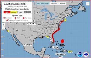
Hurricane Erin is inching closer to the Eastern Seaboard, sparking evacuation orders, storm surge warnings, and dangerous rip currents along the East Coast. As of Tuesday, the storm was positioned about 655 miles south-southeast of Cape Hatteras, North Carolina, with maximum sustained winds of 105 mph, according to the National Hurricane Center (NHC).
States of Emergency and Evacuations
Authorities in North Carolina have declared states of emergency in two coastal counties. Dare County officials issued mandatory evacuation orders for Hatteras and Ocracoke islands, urging residents and visitors to leave before seawater overtakes Highway 12 — the critical roadway connecting communities across the Outer Banks.
Dare County Emergency Management Director Drew Pearson did not mince words:
“I encourage all residents and visitors to heed the evacuation order and take action to protect themselves, to protect their property, and to get up and leave — now.”
A tropical storm warning is currently in effect for the Outer Banks from Beaufort Inlet to Duck, while a storm surge warning extends from Cape Lookout to Duck. Forecasters say life-threatening inundation of 2 to 4 feet above ground level is possible in vulnerable areas.
Why Size Matters More Than Windspeed
Though Hurricane Erin briefly reached Category 5 strength last weekend, forecasters emphasize that its sheer size is now a greater concern than wind intensity. The storm is producing tropical-storm-force winds extending up to 230 miles from its center and hurricane-force winds up to 80 miles.
Erik Heden, a warning coordination meteorologist with the National Weather Service in Morehead City, explained why impacts will still be severe despite the storm’s offshore path:
“We see some comments in the community: ‘How come we’re being impacted at the coast? The storm is well out to sea.’ That’s correct — with the center of the storm. But keep in mind, it’s hundreds of miles across.”
Mexican Drug Operation Linked to Tennessee Crash Leads to Major U.S. Indictments - USA Herald
Hurricane Erin Brings Waves, Flooding, and Erosion
The NHC projects massive waves of 15 to 20 feet or higher along the shoreline, with powerful rip currents expected from Florida to Long Island, New York. The rip current forecast map highlights high risks for swimmers and beachgoers throughout the week.
Matthew Janssen, a coastal hazards researcher at the Stevens Institute of Technology, noted the long-term risks for barrier islands like the Outer Banks:
FOLLOW US
Recent Posts

Trump Names JD Vance “Fraud Czar” As California Comes Into…

The Trial of Jesus Christ A Legal Examination of Good…

Gervonta Davis Fires Back With $20M Countersuit, Claims Accuser Ran…

KitKat Deploys Public Tracker After Thieves Steal 12 Tons of…

Saharan Dust Turns Crete’s Sky A Fiery Red As Storm…

‘Operation Never Say Die’ Exposes $50 Million Hospice Fraud Scheme…

Annie Altman Files Amended Lawsuit Against Brother Sam Altman In…
Don’t Miss It
OpenAI Isn’t Just Buying A Podcast It’s Buying Influence In The AI Narrative War
By – Samuel LopezPennsylvania Man Pleads Guilty In Federal ‘Animal Crush’ Video Case As Authorities Warn of Expanding Underground Market
By – Samuel LopezRep. Tim Burchett Warns Classified UAP Briefing Contains Explosive Information That Could ‘Set the Earth on Fire’
By – Samuel LopezNational Security Intelligence Report: Clear And Present Danger – Iran’s Cyber War Against America
By – Samuel LopezArtemis II Clears Earth Orbit, Heads Toward Moon’s Far Side
By – Tyler BrooksFormer DeRidder Mayor’s Sentencing Rescheduled for June
By – Tyler BrooksJavon Vital Commits to USC Football Program
By – Tyler BrooksBill Could Expand Early Release for Terminally Ill Inmates to 120 Days
By – Tyler Brooks
Kelly Warner Law Firm Blames USA Herald for Arizona Bar Investigation
In what appears as a desperate attempt to defend multiple allegations of fraud on the courts, the Kelly Warner Law…
By – USA Herald
Aaron Kelly Law Firm Resorts To Attacking Former Client Again On KellyWarnerLaw.com – Pattern Recognized
Attorney Aaron Kelly and his law partner Daniel Warner are currently under investigation by the Arizona Bar for legal misconduct.…
By – Jeff Watterson
Arizona Bar Opens Investigation on Attorney Aaron Kelly
USA Herald recently reported on a developing story involving Attorneys Daniel Warner and Aaron Kelly. Both Warner and Kelly have…
By – Paul O'Neal
Teacher Protection Bill Advances Unopposed in House Committee
A proposal designed to safeguard teachers from student violence is gaining momentum after clearing a House committee without objection. House…
By – Tyler Brooks
US Intel Finds Iran Retains Key Strike Capabilities Despite Weeks of Attacks
Recent U.S. intelligence assessments indicate that Iran continues to possess a substantial capacity to launch missiles and deploy drones, even…
By – Tyler Brooks
Trump Tariffs Reshape Global Trade One Year Later
One year after U.S. President Donald Trump launched sweeping tariffs, the global economic landscape shows significant shifts, with trade patterns…
By – Tyler Brooks
Oil Surges, Global Stocks Slip After Trump Renews Iran Strike Threats
Oil prices climbed sharply once again after U.S. President Donald Trump renewed warnings of intensified military action against Iran, offering…
By – Tyler Brooks
Judge Dismisses Majority of Claims In Lively Harassment Suit Against Baldoni
A federal judge has dismissed most claims brought by actress Blake Lively in her sexual harassment lawsuit against her It…
By – Tyler Brooks
Trump Ousts Attorney General Pam Bondi, Cites Private Sector Transition
US President Donald Trump has dismissed Attorney General Pam Bondi, a close ally and staunch defender of his administration, ending…
By – Tyler Brooks
Trump Ousts Attorney General Pam Bondi, Cites Private Sector Transition
US President Donald Trump has dismissed Attorney General Pam Bondi, a close ally and staunch defender of his administration, ending…
By – Tyler Brooks
Trump Targets State Farm As California Wildfire Fallout Exposes Deeper Insurance Crisis
INSIDE THIS REPORT A presidential warning shot has been fired at one of America’s largest insurers—but the implications extend far…
By – Samuel Lopez
Tennessee Congressman Warns Classified UAP Briefings Would Shake Public Faith In Government
Rep. Tim Burchett says he has been briefed by intelligence agencies on information so sensitive it would leave Americans “unglued”…
By – Samuel Lopez
The Persuasion Machine Inside AI How New Research Reveals A Quiet Trade-Off Between Influence And Truth
INSIDE THIS REPORT A massive multi-institution study has uncovered something far more concerning than AI bias—it has identified how easily…
By – Samuel Lopez
Market Analysis: Strait of Hormuz Tensions Are Quietly Straining the U.S. Insurance Market — And the Pressure Is Building
INSIDE THIS REPORT A narrow shipping lane in the Middle East is beginning to reshape risk calculations inside the American…
By – Samuel Lopez
NASA Launches Artemis II Mission, First Crewed Moon Flight Since 1972
NASA’s Artemis II mission lifted off April 1 from Kennedy Space Center in Florida, sending four astronauts on a 10-day…
By – Rachel Moore
Coral Springs Vice Mayor Found Dead, Husband Arrested
Authorities in Florida announced the shocking death of Nancy Metayer Bowen, the vice mayor of Coral Springs, whose husband has…
By – Rihem Akkouche
Magnitude 4.6 Earthquake Strikes Near Boulder Creek, Shakes Bay Area
A 4.6 earthquake near Boulder Creek rattled Santa Cruz County early Thursday, sending tremors across the Bay Area and reigniting…
By – Rihem Akkouche
Goliath Ventures Filed for Chapter 11 as Alleged $328M Crypto Scheme Unravels
A Florida crypto firm once promising sky-high returns has collapsed under the weight of federal scrutiny and investor outrage. Goliath…
By – Rihem Akkouche
Ohio State Suspends Fraternity After Student Hospitalization
The case now drawing attention under the headline Ohio State suspends Fraternity has cast a spotlight on campus safety, as…
By – Rachel Moore
Senate Vote on DHS Shutdown Ends Weeks-Long Standoff
The Senate vote on DHS shutdown unfolded in the early hours of Friday, bringing a dramatic pause to a 42-day…
By – Rihem Akkouche
7 Year-Old Girl Dies in Modesto Duplex Fire, Family Devastated
The 7 year-old girl dies in Modesto duplex fire tragedy has left a California community reeling after flames tore through…
By – Rachel Moore
Mike Fincke Space Medical Incident Stuns NASA as Mystery Illness Strikes in Orbit
A routine evening aboard the International Space Station turned into a moment of high-stakes uncertainty when the Mike Fincke space…
By – Rihem Akkouche
Arizona Man Accused of Crucifying Pastor Pushes Judge For A Quick Death Sentence
By Samuel A. Lopez | USA Herald – An Arizona courtroom is now the center of a deeply disturbing case…
By – Samuel Lopez
Trump’s Laser Talk Sparks New Questions About America’s Secret Arsenal
President Donald Trump has once again done what he often does best in moments of war and tension: he dropped…
By – Samuel Lopez
The Northern Lights Return
The Northern Lights have a chance to be visible from several northern U.S. states on Tuesday night, forecasters at the…
By – Jackie Allen
February Unemployment Up as Job Losses Surprise Economists
February Unemployment Up as the latest labor market data revealed weaker-than-expected job growth and a slight increase in the national…
By – Jackie Allen
Late-Night Attack by Venezuelan National at Florida Beach
A Late-night attack by a Venezuelan National has left a Florida community shaken after authorities say a 26-year-old man ambushed…
By – Jackie Allen
Is X down? Thousands of Users Report Access Problems
Thousands of users experienced disruptions on Tuesday afternoon when X, the social media platform owned by Elon Musk, suffered a…
By – Tyler Brooks
Trump Threatens NATO Exit, Tells Europe to ‘Go Get Your Own Oil’
President Donald Trump intensified his criticism of European allies this week, warning that the United States could abandon long-standing security…
By – Tyler Brooks
Trump Defends Iran War in Address but Leaves Key Questions Unanswered
President Donald Trump delivered a nationally televised address Wednesday night seeking to justify the ongoing war with Iran, but his…
By – Tyler Brooks
“NEARING COMPLETION” — But The War Goes On
WHAT MATTERS NOW President Trump delivered his first prime-time address on the Iran war — 33 days after it began.…
By – Samuel Lopez
HUMANITY RETURNS TO THE MOON: NASA’s Artemis II Lifts Off — First Crewed Lunar Mission In 53 Years
WHAT MATTERS NOW Four astronauts are en route to the Moon for the first time since 1972. History is being…
By – Samuel Lopez
When Allegations Become Weapons How Lawfare Is Being Used In Personal Conflicts
WHAT MATTERS NOW In courtrooms across the country, allegations are not just claims—they are leverage. When the legal system is…
By – Samuel Lopez
Health Insurers 19% Claims Refusal Raises Alarm Across ACA Marketplace
A new analysis reveals a striking reality: health insurers 19% claims refusal has become a defining feature of coverage on…
By – Rachel Moore
Hospitals Threatened by Medicaid Cuts Face Growing Crisis Nationwide
A sweeping new analysis warns that hospitals threatened by Medicaid cuts are edging toward a breaking point, with hundreds of…
By – Rachel Moore
Isometric Workouts Gain Attention as Time-Efficient Path to Better Health
For many people, fitness conjures images of long hours spent running on treadmills, powering through burpees or lifting heavy weights.…
By – Tyler Brooks
How Much Screen Time Is Safe for Kids Under Five?
New government guidance recommends that children under five should spend no more than one hour a day on screens, while…
By – Tyler Brooks
New Therapies Offer Hope for Lasting Relief From Hay Fever
A new generation of treatments is renewing hopes that seasonal allergies could one day be controlled at their source, rather…
By – Tyler Brooks
Five Practical Ways Parents Can Curb Kids’ Endless Scrolling
A recent U.S. court decision finding that Meta and Google deliberately engineered addictive social media platforms has resonated with many…
By – Tyler Brooks
Judge Allows Tiger Woods to Travel Abroad for Medical Treatment
A judge in Florida on Wednesday approved a request from Tiger Woods to leave the United States and seek care…
By – Tyler Brooks
Italy Misses Third Consecutive World Cup After Shootout Loss to Bosnia-Herzegovina
Italy, four-time World Cup champions, will not feature at this year’s tournament after a heartbreaking penalty shootout defeat to Bosnia-Herzegovina,…
By – Tyler Brooks
Men’s March Madness Elite 8 Delivers High-Stakes Drama as Title Race Tightens
The madness is reaching its boiling point. The Men’s March Madness Elite 8 has arrived, trimming the 2026 NCAA Tournament…
By – Rihem Akkouche
The World Cup Security Reckoning: Trump Warns Iran Soccer Team About Safety As War Tensions Spill Into Global Sports
By Samuel A. Lopez | USA Herald – A short Truth-Social post from President Donald Trump on Thursday morning is now…
By – Samuel Lopez
Late-Night Attack by Venezuelan National at Florida Beach
A Late-night attack by a Venezuelan National has left a Florida community shaken after authorities say a 26-year-old man ambushed…
By – Jackie Allen
Trump’s War in Iran: Congress Confronts Escalation After U.S. Strikes
Trump’s War in Iran was triggered open conflict, casualties, and renewed constitutional debate in Washington. The crisis intensified following reports…
By – Jackie AllenNo posts found.
No posts found.
 No comments yet. Be the first to comment!
