Erik Heden, a warning coordination meteorologist with the National Weather Service in Morehead City, explained why impacts will still be severe despite the storm’s offshore path:
“We see some comments in the community: ‘How come we’re being impacted at the coast? The storm is well out to sea.’ That’s correct — with the center of the storm. But keep in mind, it’s hundreds of miles across.”
Mexican Drug Operation Linked to Tennessee Crash Leads to Major U.S. Indictments – USA Herald

Hurricane Erin Brings Waves, Flooding, and Erosion
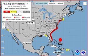
The NHC projects massive waves of 15 to 20 feet or higher along the shoreline, with powerful rip currents expected from Florida to Long Island, New York. The rip current forecast map highlights high risks for swimmers and beachgoers throughout the week.
Matthew Janssen, a coastal hazards researcher at the Stevens Institute of Technology, noted the long-term risks for barrier islands like the Outer Banks:
“The size of the storm really is correlated with higher storm surge levels over larger swaths of area, and that tends to lead to much more dramatic impacts. In some parts of the Outer Banks, the barrier islands may be a thousand feet wide in some areas. So very, very vulnerable.”


