Winter Storm Emergency Unfolds As WSSI Signals Major Disruptions Across Half The Nation
America ı By Samuel Lopez
519 0 Comments
By Samuel Lopez | USA Herald
The United States is no longer in the forecast window. This is now an active, unfolding emergency.
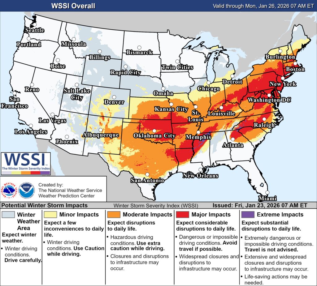
As of early Friday morning, the Winter Storm Severity Index (WSSI) issued by the National Weather Service and the Weather Prediction Center confirms what overnight model runs have made unmistakably clear: a sprawling, high-impact winter storm is actively disrupting daily life across a massive swath of the country—and in several regions, conditions are deteriorating faster than anticipated.
The updated WSSI map, valid through Monday morning, paints a stark picture. Large portions of the Southern Plains, Mississippi Valley, Ohio Valley, and Northeast are now under moderate to major impact classifications, with some corridors brushing the threshold of extreme travel disruption.
This is no longer about possibility. The atmosphere has locked in.
A Storm That Refused to Blink
Yesterday, forecasters cautioned that the synoptic setup—an entrenched Arctic air mass colliding with deep Gulf moisture—was unlikely to shift. Overnight model runs only reinforced that assessment, while sharpening the focus on where the worst impacts are now unfolding.
The most concerning zones stretch from:
- Oklahoma and North Texas through Arkansas and the Mid-South
- Across the Ohio Valley, including Kentucky, Indiana, and southern Ohio
- Into the Mid-Atlantic and Northeast, from Washington, D.C. to New York and Boston
In these regions, WSSI indicates major impacts, meaning dangerous or impossible driving conditions, widespread disruptions to infrastructure, and cascading effects on commerce, emergency services, and public safety.
What “Major Impacts” Actually Means on the Ground
The WSSI is not a snowfall map. It integrates snowfall, ice accretion, wind, ground temperatures, and timing to assess real-world consequences.
Where red shading dominates, residents should expect:
- Hazardous to impossible travel, even on treated roads
- Power outages from ice-loaded lines and wind stress
- Flight cancellations and airport ground stops
- School, court, and government office closures
- Delayed emergency response times in rural and suburban areas
In portions of Oklahoma, Arkansas, Tennessee, and Kentucky, the overlap of ice and snow is especially concerning. Ice—more than snow—is the silent disrupter, capable of paralyzing entire regions with relatively modest accumulation.
Northeast Corridor Faces Compounding Risks
While the southern and central states absorb the first blows, the Northeast is now firmly in the crosshairs.
From Washington, D.C. through New York City and into New England, WSSI shows a broad swath of moderate to major impacts, driven by a volatile mix of snow, sleet, freezing rain, and strong winds.
This matters because of population density. Even moderate impacts along the I-95 corridor translate into outsized national consequences—from supply chain interruptions to financial market delays and widespread commuter disruption.
FOLLOW US


Recent Posts

Senate Vote on DHS Shutdown Ends Weeks-Long Standoff

Eight Stunning Beaches Around the World

Key Exports at Risk Beyond Oil as Hormuz Disruption Ripples…

Nvidia Bets Big on AI Agents With New Tools, Hardware…

New Therapies Offer Hope for Lasting Relief From Hay Fever

Five Practical Ways Parents Can Curb Kids’ Endless Scrolling

Jury Verdict Against Social Media Giants Signals Turning Point for…
Don’t Miss It
Judge Blocks Pentagon Move to Halt Anthropic Tools Amid Legal Fight
By – Tyler BrooksTwo Aid Sailboats Missing After Departing Mexico for Cuba
By – Tyler BrooksTrump Signature to Appear on U.S. Currency for First Time
By – Tyler BrooksU.S. Lawmaker Urges Sarah Ferguson to Testify on Epstein Connections
By – Tyler BrooksChilling Pattern Emerges As Scientists with Nuclear, Exoplanet & UFO Ties Vanish or Die Amid Trump’s Disclosure Push
By – Samuel LopezAmerica’s Eyes On The Sky – Citizen Astronomers Step Up As Government Silence Raises Space Defense Questions
By – Samuel LopezTexas Home Pierced by Meteorite As Fireball Surge Sparks Nationwide Alarm
By – Samuel LopezTaylor Frankie Paul Video Exposes Uncomfortable Truth About Female-Perpetrated Domestic Violence
By – Samuel Lopez
Kelly Warner Law Firm Blames USA Herald for Arizona Bar Investigation
In what appears as a desperate attempt to defend multiple allegations of fraud on the courts, the Kelly Warner Law…
By – USA Herald
Aaron Kelly Law Firm Resorts To Attacking Former Client Again On KellyWarnerLaw.com – Pattern Recognized
Attorney Aaron Kelly and his law partner Daniel Warner are currently under investigation by the Arizona Bar for legal misconduct.…
By – Jeff Watterson
Arizona Bar Opens Investigation on Attorney Aaron Kelly
USA Herald recently reported on a developing story involving Attorneys Daniel Warner and Aaron Kelly. Both Warner and Kelly have…
By – Paul O'Neal
White House Unveils National AI Policy to Guide Congress
The White House on Friday introduced its long-awaited national artificial intelligence framework, aiming to prevent individual states from enacting their…
By – Tyler Brooks
Counting Calories Isn’t Enough, Experts Say: Focus on How and When You Eat
The conventional wisdom of weight management—balancing calories consumed with calories burned—may oversimplify how our bodies process food. Research now suggests…
By – Tyler Brooks
Pentagon Supply Chain Risk Label Likely to Have Limited Effect, Anthropic Says
Anthropic said Thursday that the Pentagon’s designation of the AI company as a “supply chain risk to America’s national security”…
By – Tyler Brooks
First Lady Melania Trump Showcases Humanoid Robot at Tech Summit
WASHINGTON — First Lady Melania Trump welcomed attendees to the Fostering the Future Together summit in Washington, D.C., an event…
By – Tyler Brooks
Houston Airport Lines Top Four Hours as Shutdown Strains Security Staffing
Travelers across the United States are encountering unusually long airport lines, with some of the most severe delays reported in…
By – Tyler Brooks
Philippine Transport Workers Strike as Fuel Prices Surge
Hundreds of transport workers in Manila staged a strike Thursday as soaring fuel prices continue to strain livelihoods across the…
By – Tyler Brooks
Philippine Transport Workers Strike as Fuel Prices Surge
Hundreds of transport workers in Manila staged a strike Thursday as soaring fuel prices continue to strain livelihoods across the…
By – Tyler Brooks
Musk Unveils ‘Terafab’ Plan to Boost Chip Production for Tesla, SpaceX
Billionaire entrepreneur Elon Musk on Saturday outlined a proposal to build a new semiconductor manufacturing complex designed to supply chips…
By – Tyler Brooks
Jury Finds Meta, YouTube Liable in Landmark Social Media Addiction Case
A jury in Los Angeles has delivered a significant verdict in favor of a 20-year-old woman who accused Meta and…
By – Tyler Brooks
Rocket Stocks Jump on Report SpaceX May Move Ahead With Share Sale
Rocket and space-related stocks rallied in U.S. trading Wednesday after a report indicated that billionaire Elon Musk’s SpaceX could soon…
By – Tyler Brooks
Middle East Conflict Threatens to Upend Global Air Travel Model
Once a modest waypoint for early long-distance aviation, Dubai has evolved into a central force in global air travel. In…
By – Tyler Brooks
Sora Shutdown Marks Sudden End to OpenAI’s AI Video Ambitions
The sora shutdown has sent ripples through the tech and entertainment industries, as OpenAI abruptly pulled the plug on its…
By – Rachel Moore
7 Year-Old Girl Dies in Modesto Duplex Fire, Family Devastated
The 7 year-old girl dies in Modesto duplex fire tragedy has left a California community reeling after flames tore through…
By – Rachel Moore
Namibia Blocks Elon Musk’s Starlink in Licensing Setback
In a move that underscores the collision between global ambition and local policy, Namibia blocks Elon Musk’s Starlink, denying the…
By – Rachel Moore
NASA Plan for Moon Base Shifts Course in $20 Billion Lunar Pivot
In a dramatic strategic overhaul, the NASA plan for moon base is taking center stage as the agency abandons its…
By – Rachel Moore
Dayton Webber Charged With Murder After Deadly Car Shooting
A story once defined by resilience and triumph has taken a dark and shocking turn, as Dayton Webber charged with…
By – Rihem Akkouche
US Park Police Officer Shot in DC Sparks Intense Manhunt
A violent ambush in the nation’s capital has triggered alarm after a US Park Police officer shot in DC during…
By – Rihem Akkouche
Explosion at Valero Refinery Sends Smoke Towering Over Texas Coast
A thunderous blast at a Gulf Coast facility has ignited concern after an Explosion at Valero refinery sent massive plumes…
By – Rihem Akkouche
Arizona Man Accused of Crucifying Pastor Pushes Judge For A Quick Death Sentence
By Samuel A. Lopez | USA Herald – An Arizona courtroom is now the center of a deeply disturbing case…
By – Samuel Lopez
Trump’s Laser Talk Sparks New Questions About America’s Secret Arsenal
President Donald Trump has once again done what he often does best in moments of war and tension: he dropped…
By – Samuel Lopez
The Northern Lights Return
The Northern Lights have a chance to be visible from several northern U.S. states on Tuesday night, forecasters at the…
By – Jackie Allen
February Unemployment Up as Job Losses Surprise Economists
February Unemployment Up as the latest labor market data revealed weaker-than-expected job growth and a slight increase in the national…
By – Jackie Allen
Late-Night Attack by Venezuelan National at Florida Beach
A Late-night attack by a Venezuelan National has left a Florida community shaken after authorities say a 26-year-old man ambushed…
By – Jackie Allen
Trump’s War in Iran: Congress Confronts Escalation After U.S. Strikes
Trump’s War in Iran was triggered open conflict, casualties, and renewed constitutional debate in Washington. The crisis intensified following reports…
By – Jackie Allen
Sora Shutdown Marks Sudden End to OpenAI’s AI Video Ambitions
The sora shutdown has sent ripples through the tech and entertainment industries, as OpenAI abruptly pulled the plug on its…
By – Rachel Moore
KKR to Acquire Nothing Bundt Cakes in $2 Billion Deal
The KKR to acquire Nothing Bundt Cakes deal is rising like a perfectly baked confection in the private equity world,…
By – Rachel Moore
BlackRock chief warns global recession could follow if oil prices reach $150 per barrel.
Larry Fink, the chief executive of Larry Fink and leader of the global asset management firm BlackRock, has warned that…
By – Tyler Brooks
OpenAI has Shut Down its Artificial Intelligence Video-Generation App, Sora, Less than Two Years After Its Launch
At the same time, OpenAI is ending its content partnership with Disney. The company said it decided to discontinue Sora…
By – Tyler Brooks
Oil rebounds above $100 amid mixed signals over US–Iran talks
Brent crude prices climbed back above $100 per barrel after a sharp drop earlier in the week, as uncertainty grew…
By – Tyler Brooks
Apollo to Acquire Nippon Sheet in Landmark $3.7B Deal
In a move that underscores shifting tides in global finance, Apollo to acquire Nippon Sheet has emerged as one of…
By – Rachel Moore
War Insurance Reality Americans Face Even When the Battlefield Is Overseas
By Samuel A. Lopez | USA Herald – When Americans hear news of airstrikes in the Persian Gulf, naval confrontations…
By – Samuel Lopez
Supreme Court Asked To Step In As 98-Year-Old Federal Judge Pauline Newman Fights Suspension From The Bench
[USA HERALD] – For more than four decades, one of the most influential judges in American patent law helped shape…
By – Samuel Lopez
Iran Appears To Have Conducted Its First Major Cyberattack Against A U.S. Company, Since The War Began – New Front Opens Against American Healthcare
An alleged Iran-linked cyberattack on Stryker appears to mark a dangerous turn in the conflict, pushing digital retaliation from nuisance-level…
By – Samuel Lopez
Beyond Gas Prices The Strait of Hormuz Crisis Could Hit Fertilizer, Plastics, Aluminum And Global Supply Chains
By Samuel Lopez | USA Herald – Right now, most Americans hearing about the Strait of Hormuz are thinking about…
By – Samuel Lopez
When The Files Are Finally Unsealed The Most Mind-Bending Truth May Not Be What We Expect
[USA HERALD] – There is a widespread assumption that if governments release their most highly classified files related to unidentified…
By – Samuel Lopez
Civil Rights Icon Rev. Jesse Jackson Dies at 84 As President Trump Issues Personal Tribute
[USA HERALD] — The Rev. Jesse Jackson, a towering figure of the American civil rights movement whose career spanned more than…
By – Samuel Lopez
The World Cup Security Reckoning: Trump Warns Iran Soccer Team About Safety As War Tensions Spill Into Global Sports
By Samuel A. Lopez | USA Herald – A short Truth-Social post from President Donald Trump on Thursday morning is now…
By – Samuel Lopez
Trump’s War in Iran: Congress Confronts Escalation After U.S. Strikes
Trump’s War in Iran was triggered open conflict, casualties, and renewed constitutional debate in Washington. The crisis intensified following reports…
By – Jackie Allen
Cadillac Names Inaugural Formula 1 Car MAC-26 in Tribute to Mario Andretti Ahead of 2026 Australian Grand Prix Debut
Cadillac has officially revealed the name of its first Formula 1 challenger, confirming that its 2026 car will be called…
By – Ahmed Boughalleb
Norway Tops Medal Table After Day 13 at 2026 Winter Olympics as Team USA Surges Into Second Place
With 13 days complete at the 2026 Milan Cortina Winter Olympics, Norway sits atop the overall medal standings, collecting 34…
By – Ahmed Boughalleb
Olympic Science Explained: How Figure Skaters Spin at Blinding Speeds Without Getting Dizzy
When Amber Glenn finishes her routine, the arena usually rises with her. The music builds, her blades carve a tight…
By – Tyler Brooks
Olympic Villages Run Out of Condoms at 2026 Milan-Cortina Games
Condom supplies in the Olympic Villages at the 2026 Winter Games have been temporarily depleted, the Milan-Cortina organizing committee confirmed,…
By – Tyler BrooksNo posts found.
No posts found.
 No comments yet. Be the first to comment!