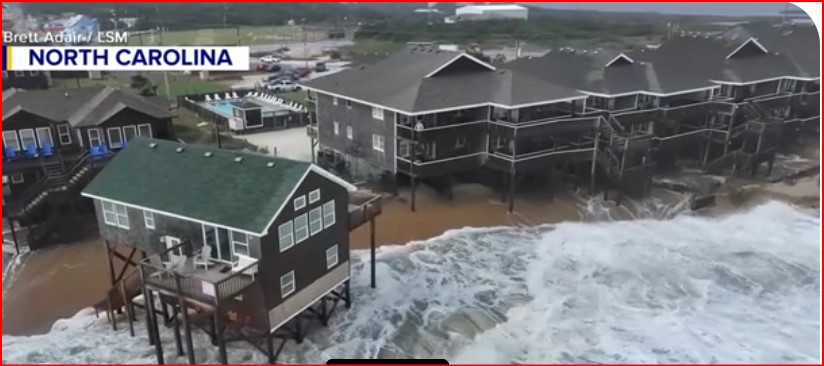
Severe Nor’easter Causes Coastal Flooding Across Multiple States
America ı By Jackie Allen
332 0 Comments
FOLLOW US


Recent Posts

Supreme Court Birthright Citizenship Case Puts U.S. Identity at a…

North Korea Test Missile to Target US Mainland Signals Escalation…

Tennessee School Bus Crash Leaves Two Students Dead, Community in…

Noelia Castillo Euthanasia Case Ends After Lengthy Legal Battle in…

American Airlines Flight Attendant Missing Case Takes Grim Turn in…

Bank of America Epstein Lawsuit $72.5M Settlement Reaches Turning Point…

Trump to Pay TSA Workers Amid Shutdown as Crisis Deepens…
Don’t Miss It
Men’s March Madness Elite 8 Delivers High-Stakes Drama as Title Race Tightens
By – Rihem AkkoucheMike Fincke Space Medical Incident Stuns NASA as Mystery Illness Strikes in Orbit
By – Rihem AkkoucheNASA Artemis II Moon Mission Launch Nears as Historic Crew Prepares for Deep Space Gamble
By – Rihem AkkoucheNo Kings Protests Planned for Saturday as Nationwide Dissent Swells
By – Rihem AkkoucheGoliath Ventures Filed for Chapter 11 as Alleged $328M Crypto Scheme Unravels
By – Rihem AkkoucheFeds Guarantee Loans for Farmers as Industry Faces Mounting Pressures
By – Rachel MooreGrand Canyon Park Reopen North Rim After Devastating Wildfire
By – Rachel MooreUN Aviation Limits Power Bank Use in Sweeping In-Flight Safety Shift
By – Rachel Moore
Kelly Warner Law Firm Blames USA Herald for Arizona Bar Investigation
5/17/17 Based on the information released in The Washington Post article on 5/17/17, the USA Herald publishes another in-depth article that…
By – USA Herald
Aaron Kelly Law Firm Resorts To Attacking Former Client Again On KellyWarnerLaw.com – Pattern Recognized
Professor Volokh thereafter filed a bar complaint against Dan Warner with the Arizona Bar. This eventually led the ABA to…
By – Jeff Watterson
Arizona Bar Opens Investigation on Attorney Aaron Kelly
USA Herald recently reported on a developing story involving Attorneys Daniel Warner and Aaron Kelly. Both Warner and Kelly have…
By – Paul O'Neal
Ohio State Suspends Fraternity After Student Hospitalization
A Developing Investigation With High Stakes The Ohio State suspends Fraternity case now moves into an investigative phase, where unanswered…
By – Rachel Moore
Iran FBI Director Email Hack Sparks Cybersecurity Alarm and Global Tensions
Expanding Pattern of Cyberattacks Stryker Incident Highlights Escalation Earlier in March, the Handala group claimed responsibility for a cyberattack targeting…
By – Rihem Akkouche
Jill Biden Agent Shooting Sparks Security Probe at Philadelphia Airport
The incident now widely referred to as the jill biden agent shooting unfolded in seconds—but its shockwaves are rippling far…
By – Rihem Akkouche
US Delay Ukraine Weapons Shipments Raises Alarm Across NATO Allies
A Fragile Balance With Global Stakes The unfolding situation surrounding US delay Ukraine weapons shipments resembles a high-wire act: steady…
By – Rihem Akkouche
Nexstar-Tegna Media Merger Lawsuit Ignites Political Firestorm and Courtroom Battle
FCC Divisions Deepen Inside the FCC, the divide is just as stark. Commissioner Anna Gomez, the agency’s lone Democrat, condemned…
By – Rihem Akkouche
Tourist Helicopter Crashes in Kauai Leave Trail of Tragedy on Remote Shore
A tourist helicopter plunged onto a remote stretch of sand along Hawaii’s rugged coastline, turning a scenic journey into a…
By – Rihem Akkouche
Tourist Helicopter Crashes in Kauai Leave Trail of Tragedy on Remote Shore
A tourist helicopter plunged onto a remote stretch of sand along Hawaii’s rugged coastline, turning a scenic journey into a…
By – Rihem Akkouche
Senate Vote on DHS Shutdown Ends Weeks-Long Standoff
Uncertain Path in the House House Speaker Mike Johnson has already criticized the piecemeal approach, calling it “shameful” to leave…
By – Rihem Akkouche
Eight Stunning Beaches Around the World
La Baia di Ieranto, Sorrentine Peninsula, Italy “Most tourists to the Amalfi Coast envision sandy shores, only to find that…
By – Tyler Brooks
Key Exports at Risk Beyond Oil as Hormuz Disruption Ripples Globally
The disruption of oil and gas flows through the Strait of Hormuz, triggered by the US-Israel conflict with Iran, has…
By – Tyler Brooks
Nvidia Bets Big on AI Agents With New Tools, Hardware Push
Nvidia, the world’s most valuable company and a central force behind the artificial intelligence surge, is doubling down on AI…
By – Tyler Brooks
New Therapies Offer Hope for Lasting Relief From Hay Fever
A new generation of treatments is renewing hopes that seasonal allergies could one day be controlled at their source, rather…
By – Tyler Brooks
7 Year-Old Girl Dies in Modesto Duplex Fire, Family Devastated
The 7 year-old girl dies in Modesto duplex fire tragedy has left a California community reeling after flames tore through…
By – Rachel Moore
Namibia Blocks Elon Musk’s Starlink in Licensing Setback
High Stakes for Connectivity in Remote Regions Starlink’s satellite network is designed to deliver high-speed internet to remote and underserved…
By – Rachel Moore
NASA Plan for Moon Base Shifts Course in $20 Billion Lunar Pivot
In a dramatic strategic overhaul, the NASA plan for moon base is taking center stage as the agency abandons its…
By – Rachel Moore
Dayton Webber Charged With Murder After Deadly Car Shooting
A Community Left Searching for Answers The transformation from celebrated athlete to murder suspect has left many grappling with disbelief—like…
By – Rihem Akkouche
US Park Police Officer Shot in DC Sparks Intense Manhunt
A Pattern of Violence Raises Concern The shooting comes just months after a deadly November incident in the District, when…
By – Rihem Akkouche
Explosion at Valero Refinery Sends Smoke Towering Over Texas Coast
A City on Edge, Then Relief As dawn broke Tuesday, the immediate danger appeared to ease, but the memory of…
By – Rihem Akkouche
Arizona Man Accused of Crucifying Pastor Pushes Judge For A Quick Death Sentence
By Samuel A. Lopez | USA Herald – An Arizona courtroom is now the center of a deeply disturbing case…
By – Samuel Lopez
Trump’s Laser Talk Sparks New Questions About America’s Secret Arsenal
On the American side, the evidence also points to a military that is pushing hard into directed energy rather than…
By – Samuel Lopez
The Northern Lights Return
The Northern Lights have a chance to be visible from several northern U.S. states on Tuesday night, forecasters at the…
By – Jackie Allen
February Unemployment Up as Job Losses Surprise Economists
According to the BLS: Producer prices rose 2.9% year-over-year through January 2026 Core PPI increased 3.6%, excluding food and energy…
By – Jackie Allen
Late-Night Attack by Venezuelan National at Florida Beach
Officials noted that the suspect had overstayed his work visa at the time of the attack. For more details on…
By – Jackie Allen
Trump’s War in Iran: Congress Confronts Escalation After U.S. Strikes
On the Republican side, most lawmakers appear to back Trump’s strategy. Sen. Tom Cotton (R-Ark.), chair of the Senate Intelligence…
By – Jackie Allen
Judge Blocks Pentagon Move to Halt Anthropic Tools Amid Legal Fight
A federal judge has handed an early legal victory to artificial intelligence firm Anthropic in its dispute with the Pentagon.…
By – Tyler Brooks
Chilling Pattern Emerges As Scientists with Nuclear, Exoplanet & UFO Ties Vanish or Die Amid Trump’s Disclosure Push
[USA HERALD] – On February 20, 2026, President Trump posted on Truth Social directing the Pentagon and other agencies to…
By – Samuel Lopez
America’s Eyes On The Sky – Citizen Astronomers Step Up As Government Silence Raises Space Defense Questions
Dashcams Home surveillance systems Personal astrophotography setups As someone who has personally reviewed and analyzed this footage, I can confirm…
By – Samuel Lopez
Texas Home Pierced by Meteorite As Fireball Surge Sparks Nationwide Alarm
[USA HERALD] – A cantaloupe-sized space rock smashed through a Houston-area roof on March 21, 2026, ricocheted through a bedroom,…
By – Samuel Lopez
Taylor Frankie Paul Video Exposes Uncomfortable Truth About Female-Perpetrated Domestic Violence
[USA HERALD] – A leaked 2023 video showing reality star Taylor Frankie Paul as the aggressor in a physical confrontation…
By – Samuel Lopez
White House Unveils National AI Policy to Guide Congress
The White House on Friday introduced its long-awaited national artificial intelligence framework, aiming to prevent individual states from enacting their…
By – Tyler Brooks
New Therapies Offer Hope for Lasting Relief From Hay Fever
A new generation of treatments is renewing hopes that seasonal allergies could one day be controlled at their source, rather…
By – Tyler Brooks
Five Practical Ways Parents Can Curb Kids’ Endless Scrolling
A recent U.S. court decision finding that Meta and Google deliberately engineered addictive social media platforms has resonated with many…
By – Tyler Brooks
Counting Calories Isn’t Enough, Experts Say: Focus on How and When You Eat
Food Structure and Calorie Absorption How food is prepared and chewed affects the calories absorbed. A handful of almonds contains…
By – Tyler Brooks
War Insurance Reality Americans Face Even When the Battlefield Is Overseas
However, most Americans are unaware that their own policies contain similar boundaries. If a missile strike or military action directly…
By – Samuel Lopez
Supreme Court Asked To Step In As 98-Year-Old Federal Judge Pauline Newman Fights Suspension From The Bench
[USA HERALD] – For more than four decades, one of the most influential judges in American patent law helped shape…
By – Samuel Lopez
Iran Appears To Have Conducted Its First Major Cyberattack Against A U.S. Company, Since The War Began – New Front Opens Against American Healthcare
Public reporting has pointed to a likely abuse of Microsoft Intune-style device management functions. Sophos threat intelligence director Rafe Pilling…
By – Samuel Lopez
The World Cup Security Reckoning: Trump Warns Iran Soccer Team About Safety As War Tensions Spill Into Global Sports
By Samuel A. Lopez | USA Herald – A short Truth-Social post from President Donald Trump on Thursday morning is now…
By – Samuel Lopez
Trump’s War in Iran: Congress Confronts Escalation After U.S. Strikes
On the Republican side, most lawmakers appear to back Trump’s strategy. Sen. Tom Cotton (R-Ark.), chair of the Senate Intelligence…
By – Jackie Allen
Cadillac Names Inaugural Formula 1 Car MAC-26 in Tribute to Mario Andretti Ahead of 2026 Australian Grand Prix Debut
Lowdon has previously spoken about Andretti’s early encouragement during the team’s formation stages, noting that the racing legend asked him…
By – Ahmed Boughalleb
Norway Tops Medal Table After Day 13 at 2026 Winter Olympics as Team USA Surges Into Second Place
With 13 days complete at the 2026 Milan Cortina Winter Olympics, Norway sits atop the overall medal standings, collecting 34…
By – Ahmed Boughalleb
Olympic Science Explained: How Figure Skaters Spin at Blinding Speeds Without Getting Dizzy
When Amber Glenn finishes her routine, the arena usually rises with her. The music builds, her blades carve a tight…
By – Tyler Brooks
Olympic Villages Run Out of Condoms at 2026 Milan-Cortina Games
Condom supplies in the Olympic Villages at the 2026 Winter Games have been temporarily depleted, the Milan-Cortina organizing committee confirmed,…
By – Tyler BrooksNo posts found.
No posts found.
 No comments yet. Be the first to comment!